Файл:Montenegro Map.png

Повна роздільність (2427 × 1807 пікселів, розмір файлу: 1,03 МБ, MIME-тип: image/png)
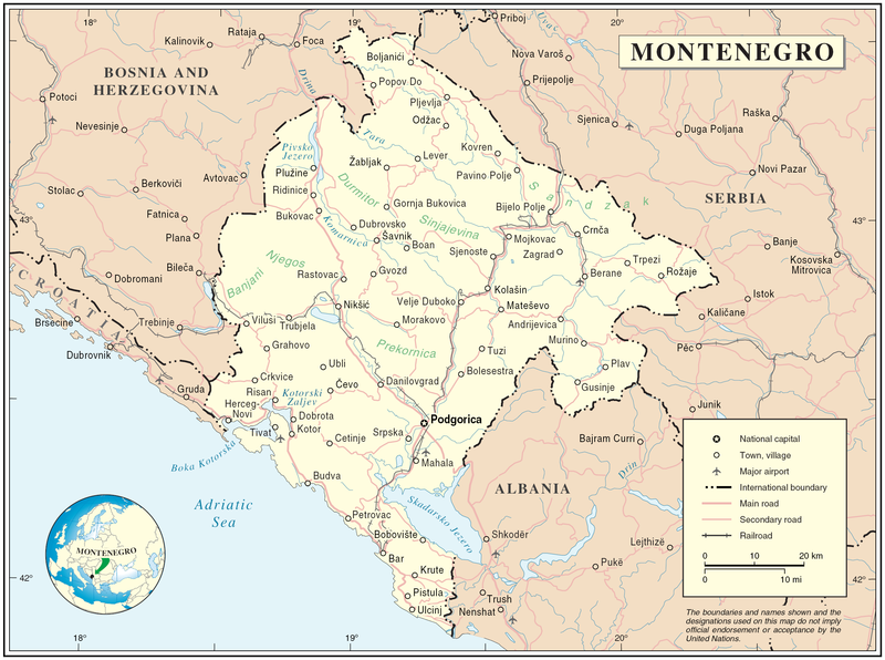
Map of Montenegro
| Опис | Map of Montenegro | |||
| Час створення | ||||
| Джерело | The Cartographic Section of the United Nations (CSUN) | |||
| Автор | Cartographer of the United Nations | |||
| Ліцензія (Повторне використання цього файлу) |
|

Історія файлу
Клацніть на дату/час, щоб переглянути, як тоді виглядав файл.
| Дата/час | Мініатюра | Розмір об'єкта | Користувач | Коментар | |
|---|---|---|---|---|---|
| поточний | 17:03, 10 березня 2007 | | 2427 × 1807 (1,03 МБ) | Minestrone | Map of Montenegro {{Information |Description=Map of Montenegro |Source=The Cartographic Section of the United Nations (CSUN) |Date=2007-03-10 |Author=Cartographer of the United Nations |Permission={{Template:UN map}} and the cartographer of the UN [ |
Використання файлу
Така сторінка використовує цей файл:
Глобальне використання файлу
Цей файл використовують такі інші вікі:
- Використання в als.wikipedia.org
- Використання в ar.wikipedia.org
- Використання в avk.wikipedia.org
- Використання в be-tarask.wikipedia.org
- Використання в bg.wikipedia.org
- Використання в cs.wikipedia.org
- Використання в cy.wikipedia.org
- Використання в de.wikipedia.org
- Використання в el.wikipedia.org
- Використання в en.wikipedia.org
- Використання в fa.wikipedia.org
- Використання в fr.wikipedia.org
- Використання в gag.wikipedia.org
- Використання в gd.wikipedia.org
- Використання в hr.wiktionary.org
- Використання в ia.wikipedia.org
- Використання в incubator.wikimedia.org
- Використання в io.wikipedia.org
- Використання в ka.wikipedia.org
- Використання в la.wikipedia.org
- Використання в ms.wikipedia.org
- Використання в nl.wikipedia.org
- Використання в pl.wikipedia.org
- Використання в pl.wiktionary.org
- Використання в pnb.wikipedia.org
- Використання в ps.wikipedia.org
- Використання в rm.wikipedia.org
- Використання в roa-tara.wikipedia.org
- Використання в ro.wikipedia.org
- Використання в ro.wikivoyage.org
- Використання в ru.wikipedia.org
Переглянути сторінку глобального використання цього файлу.